
スーパー地形 - GPS対応地形図アプリ
Category : Maps & NavigationVersion: 4.6.17
Size:16.7 MBOS : Android 5.0+
Developer:kashmir3d
 Download
 With over 100 types of maps at your disposal, including those from the Geographical Survey Institute, the Super Terrain app offers an expansive platform for outdoor enthusiasts. From mountain climbing to casual strolls through town, these maps can be used to their fullest potential, leveraging height differences to enhance your experience.
The app was honored with the 2018 Japan Cartographic Society Award for Best Work, a testament to its excellence and utility.
- Utilize "super terrain data" that highlights terrain with unique technology, enhancing your navigation experience.
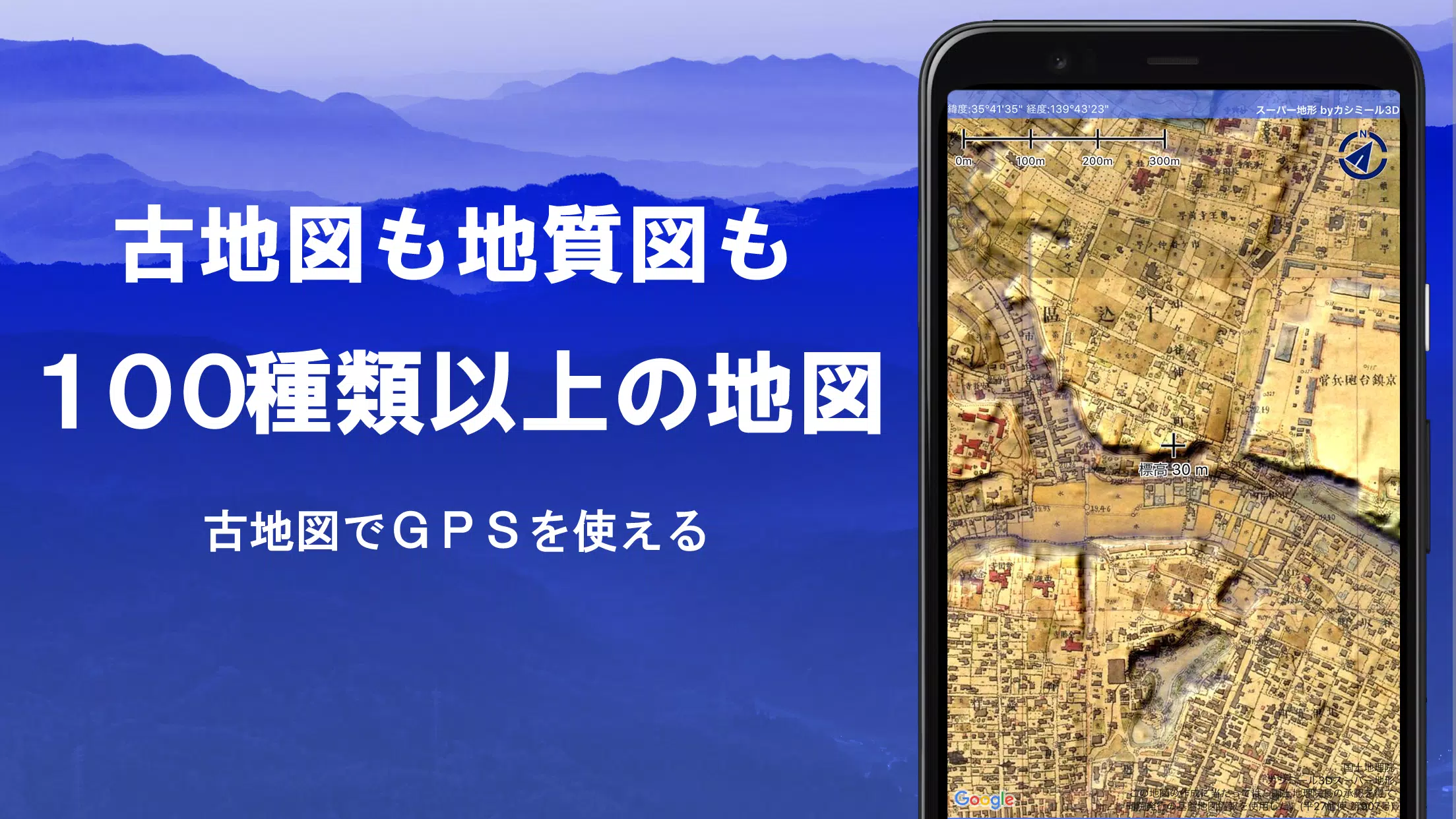
- Access a wide variety of maps from the Geospatial Information Authority of Japan, including topographic, geological, historical, and prewar Ordnance Survey maps.
- Record tracks (trajectories) using the GPS function, with the ability to input/output and edit GPX logs.
- Benefit from features designed to support urban exploration, mountain climbing, and other outdoor activities, such as GPS navigation with audio cues, and data recording and editing capabilities.
- Use the visibility determination function for creating cross-sectional diagrams, aiding in observation and radio communication, with the option to display buildings.
- Enjoy a 360° panoramic view function that helps identify mountains, along with the ability to display the sun, moon, and GPS points.
- Experience seamless offline use with GPS functionality, bulk map downloads, and a map cache feature, ideal for areas without radio signals.
- Associate photos with specific points on the map.
- View contour lines generated from elevation data and display MGRS grids (UTM grids).
- Read, display, and edit GIS data from GeoJSON files, and draw custom shapes.
- Use the app internationally and print maps or output them as PDFs.
- Enhance visibility with a dark theme option.
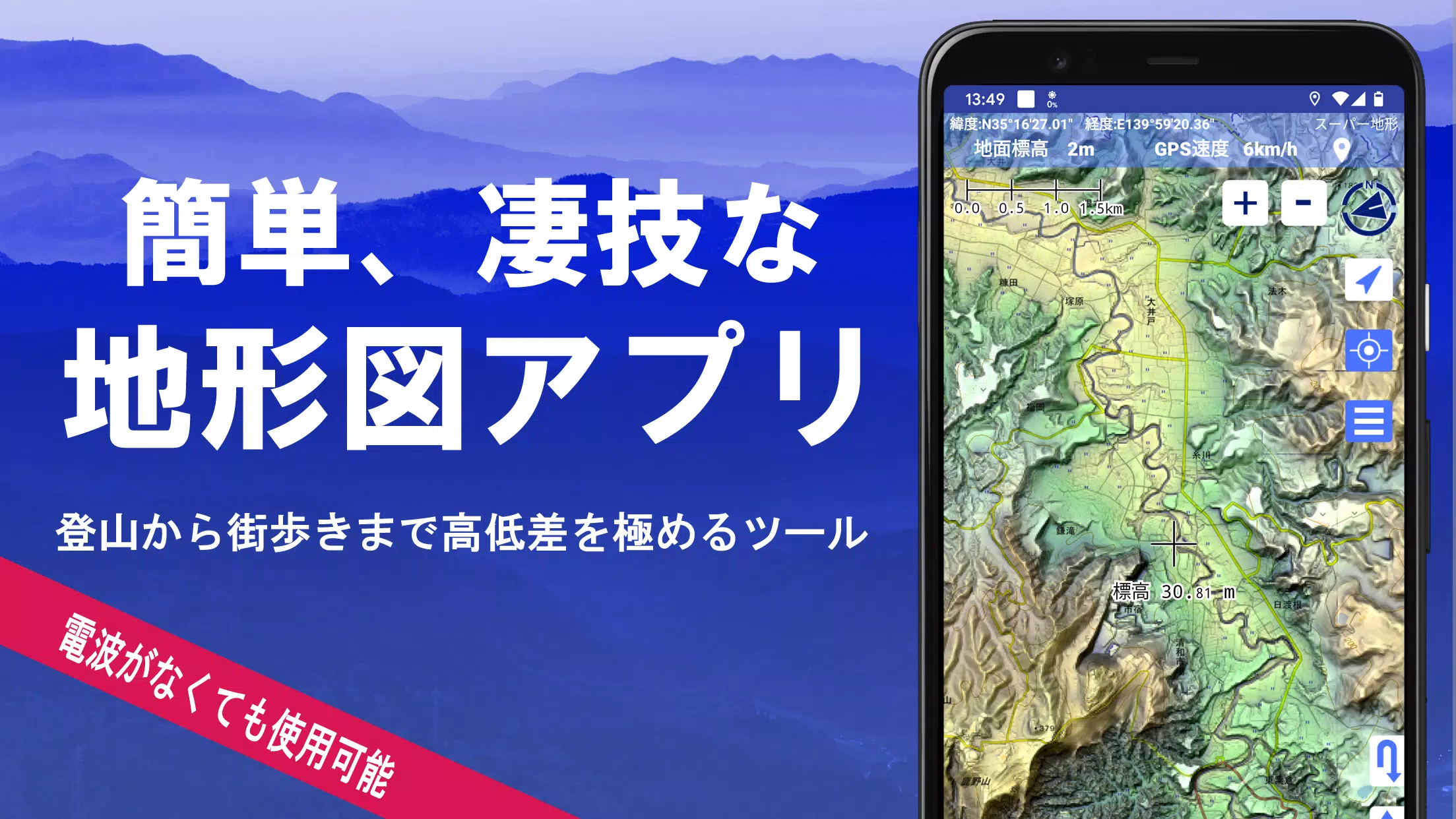
1. A Wealth of Maps at Your Fingertips
Explore more than 100 types of maps, including combinations of our proprietary super topographic data and maps from the Geospatial Information Authority of Japan, such as hazard maps. Note that aerial photographs may not be available in certain age groups, with "latest" and "around 1974" having broader coverage. Super terrain data maps are available for free for the first 5 days after installing the app.
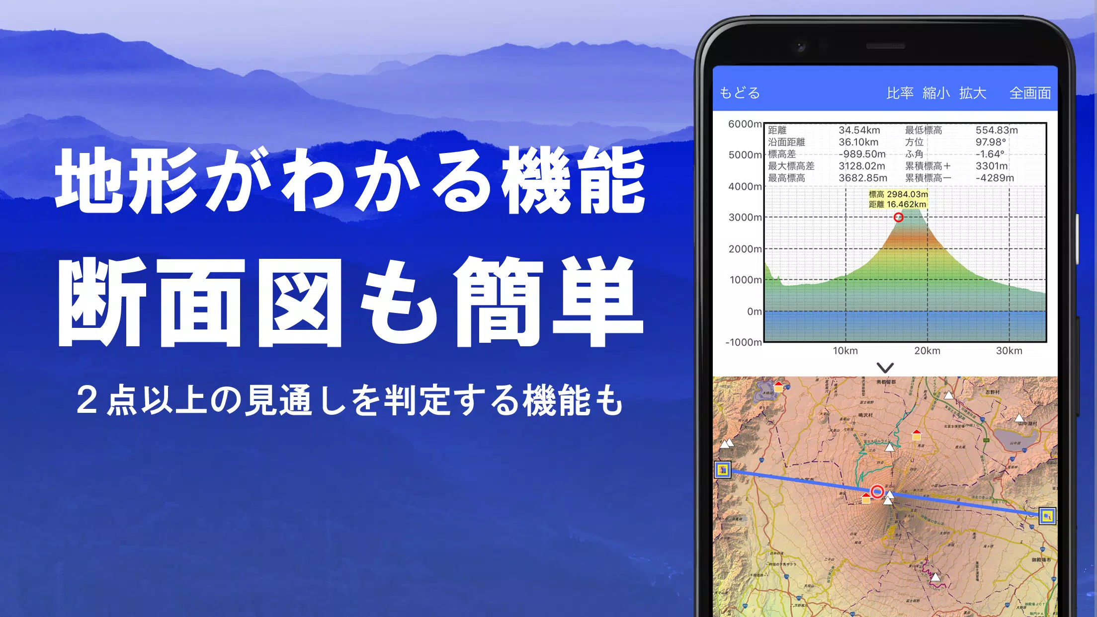
2. Cross Sections and Outlooks
Effortlessly create cross-sectional diagrams through any point on the map. The app includes a well-known visibility judgment function from Kashmir 3D, accounting for Earth's curvature and atmospheric differences. This is invaluable for route planning, assessing wireless visibility, and understanding terrain. When PLATEAU building data is available, cross-sections can include building details.
3. Elevation Palette Function
Customize your map experience with the elevation palette function, allowing you to change the map background color in 1cm increments to your preferred gradient.
4. Panoramic View
View a panoramic observation map that identifies mountain names from any point. This 360° panorama links with your smartphone's compass, aiding in mountain identification. Display the sun and moon, including moon phases, for experiences like Diamond Fuji and Pearl Fuji. You can also view GPS point locations and create panoramic views of mountains abroad.
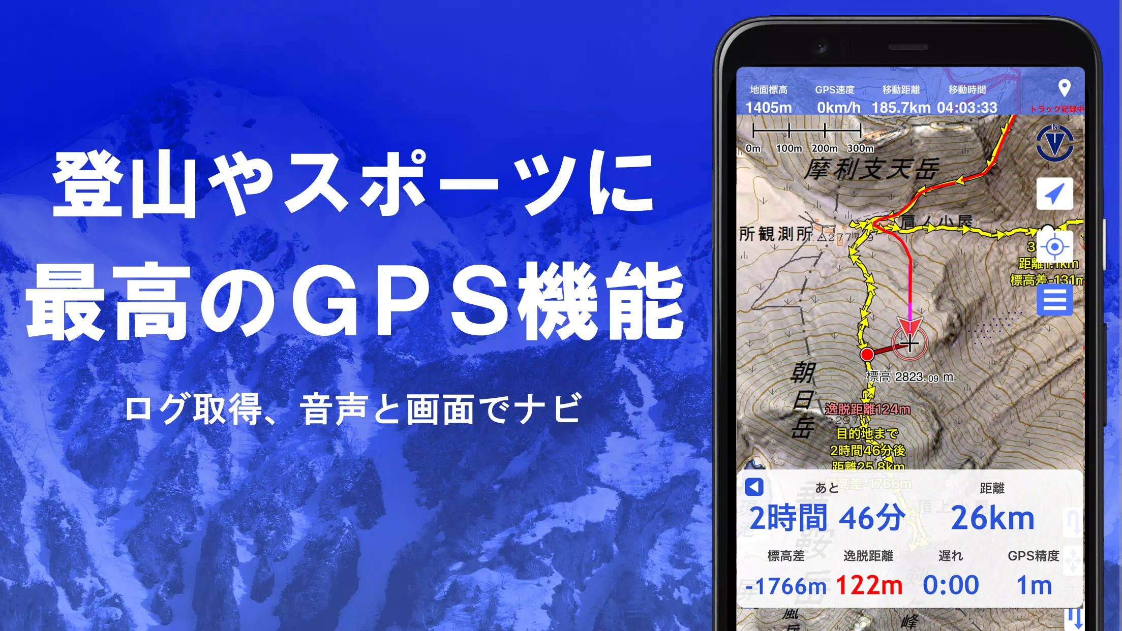
5. GPS Function
Leverage your smartphone's GPS to obtain location information and record tracks. The app uses high-precision positioning, perfect for serious mountain climbing and outdoor activities. Graphically display recorded tracks with parameters such as elevation gain, speed, time, and elapsed time. The point alarm function alerts you with voice and sound when approaching a designated point. Display photos associated with these points and send the map center position to NaviCon.
6. GPS Track Summary Playback
Replay track summaries with ease. The app automatically matches and displays photos from your smartphone based on their timestamps. Tap an icon at the photo location to view the image.
7. GPS Navigation Function
Navigate preset tracks using your smartphone's GPS with the Track Navi function. If you stray from the path, you'll be alerted by voice or sound, ensuring you never get lost while climbing. Additionally, utilize route navigation for urban exploration and point navigation for targeting specific locations.
8. GPS Data Editing Function
Manage GPS-related point, route, and track data within folders, displayed in an easy-to-read tree format. Create tracks directly on the map and import/export data in GPX format from mountain climbing websites.
9. Map Usage Outside the Service Area (Offline)
Continue using maps in remote areas without signals through bulk downloads, ensuring all scale maps of the specified area are accessible. A cache function further enhances offline use, preventing scenarios where maps are unavailable on-site.
10. Map History Function
The app remembers your viewed locations, allowing you to return to previous spots easily.
11. Custom Map Compatibility
Import and use custom maps created with Kashmir 3D's map cutter, displaying your own or scanned maps. When using the map cutter, divide each image into approximately 256 x 256 pixels and send the resulting kmz file to Super Terrain via email or Cloud Drive.
12. GeoJSON Compatibility
Display and edit points, linestrings, and polygons from GeoJSON files, with the ability to draw new shapes.
13. Print/PDF Output
Print any map area at a specified scale or create a PDF for your records.
14. Cooperation with Other Apps
Input and output GPS data in GPX, KML, and GDB formats, allowing data exchange with other apps, PC software like Kashmir 3D, and trajectory data from mountain climbing sites.
15. Backup Function
Back up all app data (excluding cached maps) and remove it from your smartphone. This data can be restored if the app is deleted or your device malfunctions. An automatic backup feature using Google Drive ensures your data is always up-to-date. Refer to the manual for detailed instructions.
16. Billing Function
Some features, such as maps using super terrain data, GPS track functions, and cross-sectional views, require in-app purchases. After payment, the number of search results for place names increases.
- Fees: Annual payment of 780 yen/year.
- Free Trial: Use the app for free for the first 5 days after installation. After this period, some features and maps may become unavailable unless you make a purchase.
- Confirmation and Cancellation: Check and cancel automatic updates through Google Play by selecting "Regular Purchase" from the menu and choosing "Super Terrain".
- Price Revision: Prices may be revised with future enhancements, making early purchases advantageous.
17. Terms of Use
The copyright holder and developer are not responsible for the outcomes of using this application. Upon first use of GPS, you'll be prompted to allow location services. Continuous GPS use can drain your battery, so carry a spare if your device is used for emergency communications. For detailed navigation instructions, refer to the PDF guide at https://www.kashmir3d.com/online/superdemapp/superdem_navi.pdf. Note that some smartphones may interrupt or fail to record tracks due to power-saving features; turning off the screen may allow recording to continue temporarily, but this is not a permanent solution.


- Apple to Preload Gaming App on New Devices This Year 5 days ago
- Konami New Project Announcement Stage | Everything Announced 1 weeks ago
- Borderlands 4 Photo Mode Arrives After Launch 1 weeks ago
- Hazelight Trip Awarded to Streamers for Secret Level Win 2 weeks ago
- Schedule I Update 0.3.4 Adds Pawn Shop, 'Fancy Stuff,' and More 2 weeks ago
- Seven Knights Idle Adventure kicks off Omniscient Reader crossover with new heroes and returning characters from last year\'s event 2 weeks ago
-

Personalization / 1.0.0 / by DigitalPowerDEV / 11.10M
Download -

Video Players & Editors / v1.02 / by TateSAV / 13.80M
Download -

Lifestyle / 1.5 / by BetterPlace Safety Solutions Pvt Ltd / 9.60M
Download -

Productivity / 2.8 / 10.16M
Download


-
 All Passwords and Padlock Combinations in Lost Records: Bloom and Rage
-
 30 best mods for The Sims 2
-
 Best Android PS1 Emulator - Which PlayStation Emulator Should I Use?
-
 Tokyo Game Show 2024 Dates and Schedule: Everything We Know So Far
-
 Leaked Footage Unveils Mythical Epic: Black Myth: Wukong
-
 Android welcomes "Dynasty Legends" style game, "Otherworld Three Kingdoms"